
Photogrammetry is a vast and evolving field that has gained significant popularity across various industries. It is widely used in fields such as architecture, forestry, agriculture, cartography, and archaeology. This article introduces the fundamental concepts of photogrammetry, explaining how it works, common applications, required hardware, and when to use it.
What Is Photogrammetry?
Photogrammetry is the process of obtaining reliable measurements from photographs. The term itself derives from Greek: “Photos” (light), “Gramma” (writing or drawing), and “Metron” (to measure). While traditionally applied to photographs, some definitions extend photogrammetry to include measurements derived from other forms of electromagnetic radiation.
Photogrammetry is a type of remote sensing that involves capturing images and determining corresponding points in overlapping images. Using computational processing, the software reconstructs real world 3D objects of the by analyzing the spatial relationships between points.
Modern photogrammetry software integrates drone GPS data, which enhances spatial accuracy. The process results in outputs such as dense point clouds, textured 3D models, orthophoto maps, and digital terrain models. Due to the high computational requirements, a high-performance PC is recommended for processing photogrammetry data.
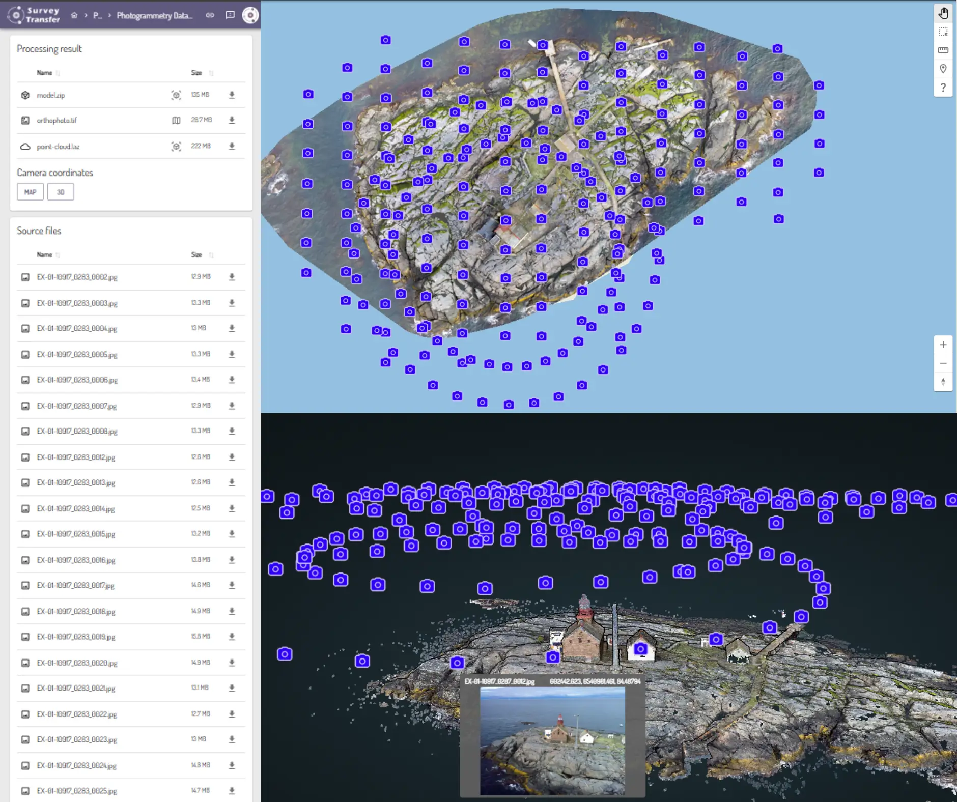
The output files of photogrammetry include point clouds, orthomosaics, digital elevation models (DEM), and 3D models. These files can be large and challenging to share, making SurveyTransfer an essential tool for data sharing and collaboration. Visit the SurveyTransfer website for more details.
What Is Photogrammetry Used For?
Architecture and Heritage Preservation
Photogrammetry is extensively used for building facade surveys, motion analysis, deformation measurements, and historic building documentation. It aids in condition surveys, remodeling, pre-design analysis, and Smart City projects.
Forestry
Photogrammetric data is valuable for forest mapping, damage assessment (e.g., pest infestation), and tree height measurement. By generating digital surface and terrain models (DSM & DTM), tree height, canopy volume, and trunk diameter can be accurately determined.
Agriculture
Aerial photogrammetry allows for crop mapping, soil moisture analysis, and precision agriculture. Farmers use it to evaluate sowing success, weed growth, and nutrient distribution through vectorized maps.
Cartography
Aerial photogrammetry produces highly detailed maps that include topography, vegetation, buildings, infrastructure, and hydrography. Local governments use these maps for urban planning, land management, and infrastructure development.
Manufacturing and Engineering
In manufacturing, photogrammetry assists in robot calibration, crash test analysis, and machine tool design. Some mining and construction machines use photogrammetric sensors to measure material volume in real-time. Self-driving cars also rely on photogrammetry and LiDAR technology for real-time road analysis.
Archaeology
Photogrammetry is crucial for excavation mapping, artifact documentation, and site reconstruction. It allows researchers to create 3D models of ruins, artifacts, and excavation sites for further study.
Medicine and Physiology
Photogrammetry plays a key role in plastic surgery, dental procedures, and musculoskeletal analysis. It is also used in custom orthopedic shoe manufacturing and 3D reconstruction of vascular networks for medical research.
Natural Sciences
Researchers use photogrammetry to study land movement, glacier changes, and raw material distribution. It is particularly useful for fluid flow analysis and geological surveys.
Visual Effects & Gaming
Photogrammetry is a game-changer in video game development and CGI effects. It helps create realistic 3D environments, motion capture models, and AR/VR experiences.
The Technology Behind 3D Photogrammetry
Photogrammetry requires a combination of hardware and software to achieve highly accurate 3D reconstructions. The choice of equipment and tools directly affects the quality and precision of the final model.
Data Capture in Photogrammetry
In the photogrammetry process — whether terrestrial close-range or aerial — effective data capture is crucial for producing accurate 3D models. Key considerations during data acquisition include:
- Focal Length: Maintaining a consistent focal length ensures uniformity across images, aiding in precise modeling. Adjusting the focal length affects the field of view and depth of field, influencing the level of detail captured.
- Position and Orientation: Systematically varying the camera’s position and orientation allows for comprehensive coverage of the subject. Capturing overlapping images from multiple angles ensures that all surfaces are documented, facilitating accurate 3D reconstruction.
- Aperture: A narrow aperture (higher f-number) increases depth of field, keeping more details in focus. A wider aperture (lower f-number) allows more light in but may reduce sharpness in some areas.
- Shutter Speed: A fast shutter speed reduces motion blur, especially when capturing images from drones or handheld cameras. A slower shutter speed can be used in stable conditions to allow more light into the camera.
- Photosensitivity (ISO): A lower ISO setting reduces noise and improves image clarity, but requires more light. A higher ISO is useful in low-light conditions but can introduce graininess.
- Expose Correctly: Proper exposure ensures that image details are preserved. Balancing aperture, shutter speed, and ISO is essential for capturing well-lit images without overexposure or loss of detail in shadows.
Cameras
The quality of digital images is crucial for accurate photogrammetry results. High-resolution cameras with minimal lens distortion yield the best results. Depending on the application, DSLRs, mirrorless cameras, and drone cameras are commonly used.
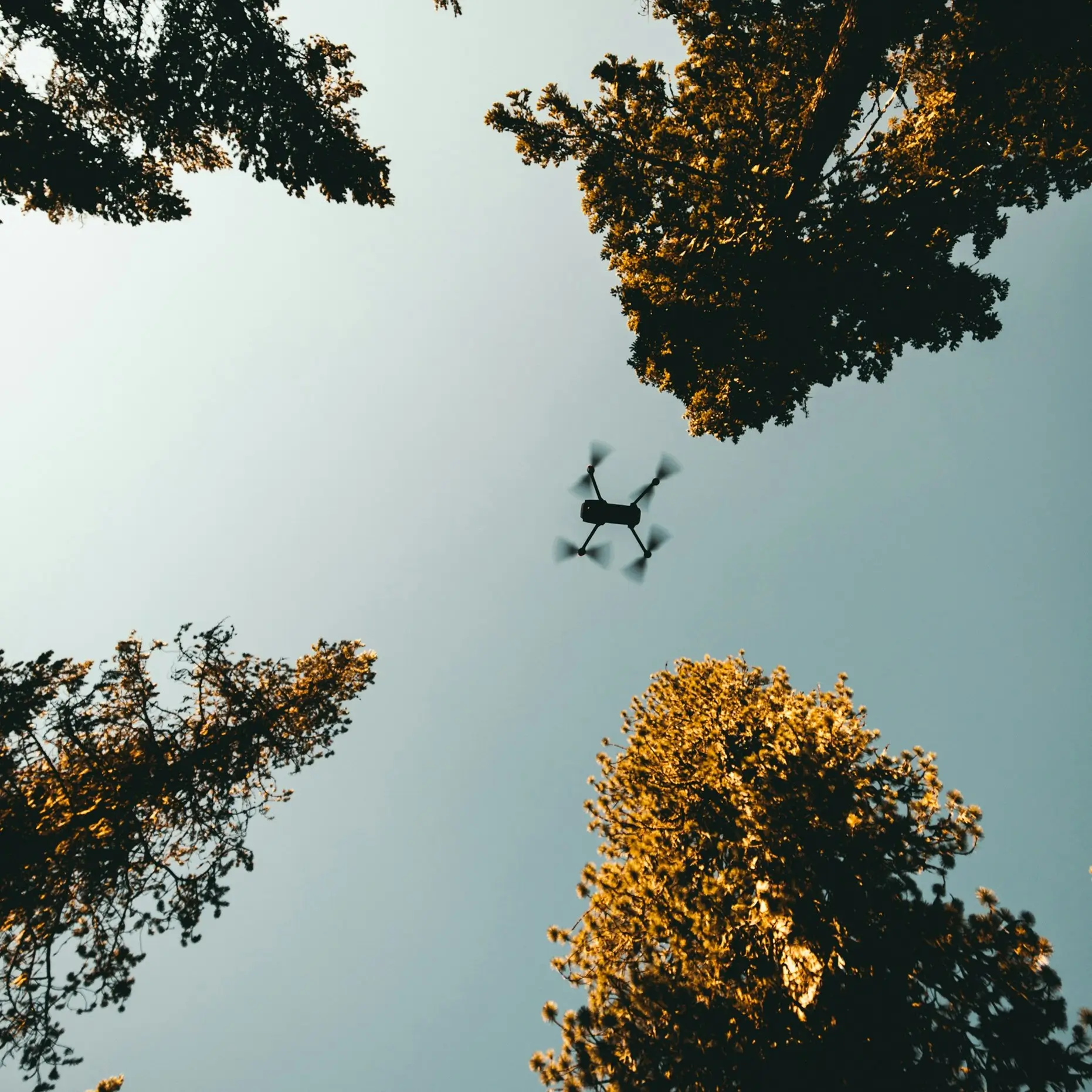
Drones
Drones equipped with high-resolution cameras and GPS/IMU sensors capture images efficiently over large areas. They are widely used in surveying, mapping, and agricultural monitoring.
Processing Software and other Photogrammetry Solutions
Several software solutions process photogrammetric data, including:
- SurveyTransfer – A web-based platform for fast photogrammetry processing and photogrammetric data sharing.
- Agisoft Metashape – Comprehensive processing for aerial and close-range photogrammetry.
- Pix4D – Ideal for drone photogrammetry and mapping.
- RealityCapture – Fast processing with advanced bundle adjustment algorithms.
- Autodesk ReCap – Used in architecture and construction.
How Does Photogrammetry Work?
1. Camera Alignment (Structure from Motion – SfM)
Photogrammetry software identifies matching points in overlapping images to determine camera positions and refine calibration parameters. This process results in a sparse point cloud, calculated using the Structure from Motion (SfM) algorithm.
2. Dense Point Cloud Generation
Using estimated camera positions, the software generates a densely sampled 3D point cloud, which forms the foundation for model reconstruction.
3. Mesh Creation & Texturing
The software reconstructs the object’s geometry and surface using triangulated mesh algorithms, such as Poisson reconstruction. Texturing is then applied using UV mapping, which wraps image data onto the 3D model for realistic visualization.
Photogrammetric Mapping & Photogrammetry Accuracy
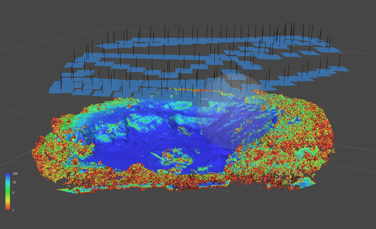
The accuracy of photogrammetric measurements depends on several factors, including camera quality, ground control points (GCPs), and the processing software used. By aligning images and analyzing overlapping areas, the software reconstructs 3D models with a high level of precision. On the image below blue areas represent high confidence of data which means higher accuracy and red areas represent lower accuracy.
Factors affecting accuracy:
- Ground Control Points (GCPs): These are strategically placed, highly accurate reference points that improve spatial accuracy. Using GCPs ensures that the model aligns correctly with real-world coordinates.
- Tie Points and Bundle Adjustment: The identification of tie points across multiple images, along with the use of coded targets, helps establish a reliable 3D structure. The bundle adjustment process further refines camera positions and orientations, enhancing overall accuracy.
- Lens Distortion Correction: Photogrammetry software compensates for lens distortion, ensuring that measurements are not skewed by camera imperfections.
- Lighting Conditions: Proper lighting conditions during data capture reduce errors in image processing and improve feature detection.
- Overlapping Images: The higher the overlap between images, the better the software can calculate object dimensions and reconstruct real-world objects with precision.
By using proper data capture techniques and high-quality processing software, photogrammetry can achieve sub-centimeter accuracy, making it a valuable tool for mapping, engineering, and scientific applications.
Share Your 3D Data With SurveyTransfer!
The output files of photogrammetry processing can be high quality point clouds, high resolution orthomosaics, digital elevation models (DEM) and 3D models. However, the large file sizes can make sharing with clients and colleagues challenging and time-consuming. SurveyTransfer offers a fast, web-based solution for viewing and sharing photogrammetry data. Visit the official website to learn more!
Conclusion: The Power of Photogrammetry
Photogrammetry is a powerful tool for 3D modeling and measurement, used across multiple industries. By leveraging advanced hardware and software, professionals can generate highly accurate digital reconstructions.
The key steps include:
- Camera Alignment (SfM & Tie Points Detection)
- Dense Point Cloud Generation
- Mesh Creation & Texturing
With continuous advancements, photogrammetry is set to play an even bigger role in mapping, engineering, medicine, and digital entertainment.
If you really liked what you read than you can share it with your friends. 🙂
Did you like what you read? Do you want to read similar ones?