
A shapefile is a widely recognized vector data format used within Geographic Information Systems (GIS) to store, visualize, and analyze geographic data. These versatile files support efficient spatial analysis and mapping across various sectors, such as urban planning, agriculture, environmental management, and transportation.
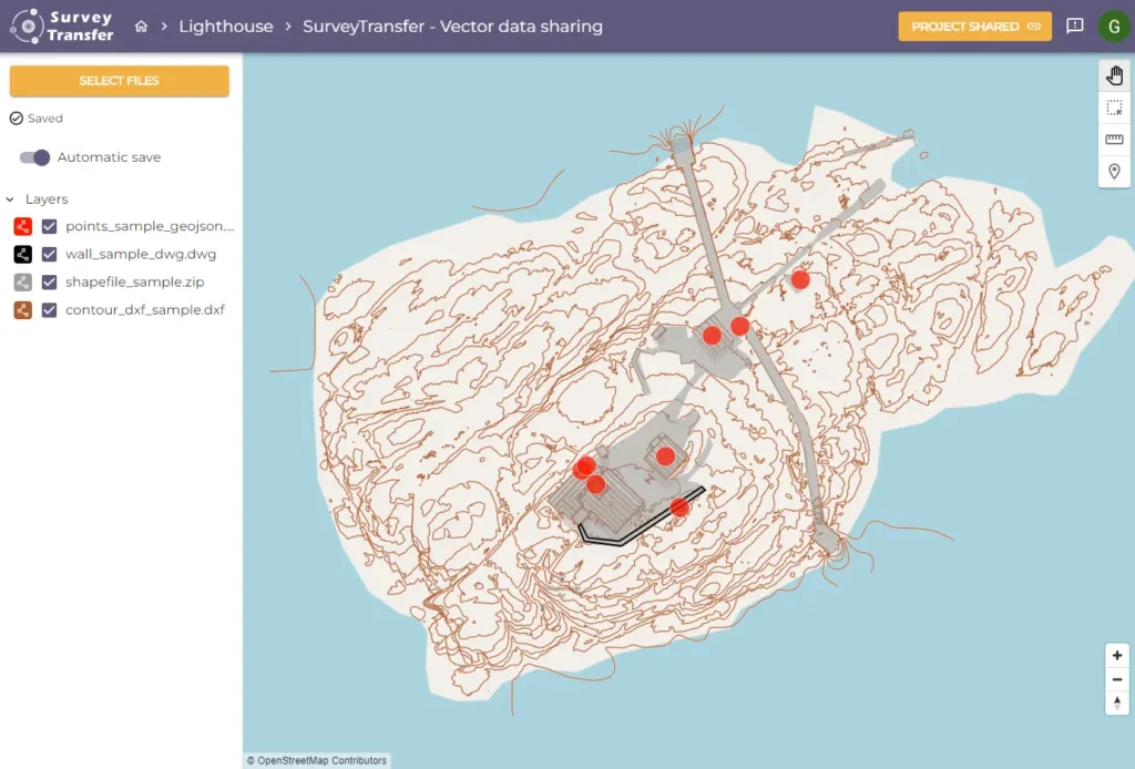
Managing shapefiles can sometimes present difficulties, especially in collaborative environments. SurveyTransfer offers an intuitive solution, simplifying the process of uploading, visualizing, and securely sharing shapefile data online. In this guide, you’ll explore the essentials of shapefiles, including their functionality, benefits, and how SurveyTransfer enhances your workflow.
What Is a Shapefile?
Originally developed by ESRI (Environmental Systems Research Institute), shapefiles store geographic information as vector data, including points, lines, and polygons. This format quickly became a GIS industry standard due to its compatibility, ease of use, and robust data management capabilities. Its popularity stems from straightforward integration with numerous GIS software platforms.
Exploring the Shapefile Format
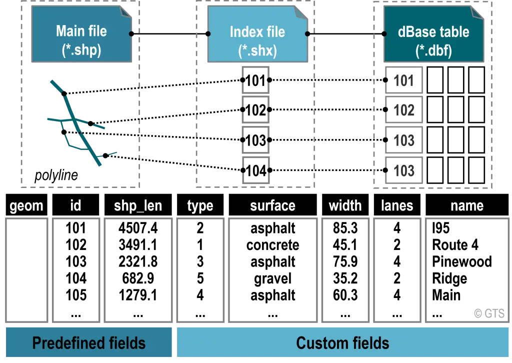
Understanding the shapefile format involves recognizing the specific role of each file component. The .shp file records geometry, such as spatial locations and coordinates. The .shx file indexes the geometric data, allowing for quicker data access. Attributes, such as area, land use type, or population, are stored in the .dbf file. Additionally, an optional .prj file defines the coordinate system used to ensure proper spatial referencing across GIS platforms.
Comparing Shapefiles and GeoJSON
Shapefiles and GeoJSON formats each have unique advantages. Shapefiles are well-supported by traditional GIS software, making them ideal for handling complex spatial data and extensive attribute management. In contrast, GeoJSON, a single-file format, provides better compatibility with modern web applications. Choosing between the two formats typically depends on project requirements, software compatibility, and data-sharing needs.
Opening and Utilizing Shapefiles
Opening shapefiles with GIS software such as ArcGIS or QGIS is straightforward—simply load the .shp file, and the software automatically associates it with its related .dbf and .shx files. This enables users to quickly view, analyze, and modify geographic data.
However, sharing shapefiles can be complicated due to their multi-file structure. According to SurveyTransfer’s guide on sharing vector maps, leveraging cloud-based solutions designed specifically for geospatial data makes this process much simpler. SurveyTransfer allows seamless uploading, visualization, and sharing of shapefiles, eliminating the need for recipients to install specialized software.
Applications of Shapefiles in Various Industries
Shapefiles support numerous practical applications across diverse industries. In urban planning, they help manage zoning maps, infrastructure layouts, and property boundaries. In agriculture, shapefiles are used for detailed soil mapping and precise agricultural practices. Environmental managers rely on shapefiles for conservation mapping and habitat analysis, while transportation planners use them for road network mapping and logistics optimization.
Advantages of Using Shapefiles
Shapefiles offer several key advantages, including extensive compatibility with GIS software, robust handling of attribute data, and clear representation of spatial data through points, lines, and polygons. Their wide acceptance in professional environments makes them a reliable choice for many GIS practitioners, enhancing data accuracy and productivity.
Conclusion
Shapefiles continue to be essential tools for spatial analysis due to their adaptability, compatibility, and comprehensive representation of geographic data. Understanding shapefiles and leveraging tools like SurveyTransfer can greatly enhance productivity, collaboration, and effective decision-making across your geospatial projects.
Ready to optimize your shapefile workflows?
Start simplifying shapefile sharing with SurveyTransfer today!
If you really liked what you read than you can share it with your friends. 🙂
Did you like what you read? Do you want to read similar ones?