
Accelerate Your 3D Modelling Survey Workflow
Accurate 3D modelling surveys are essential for construction, infrastructure, mining, and environmental projects. SurveyTransfer makes creating, visualizing, and sharing your 3D survey models simple and intuitive. Quickly process drone-captured data and seamlessly collaborate with your team or clients online. Streamlined workflow from data collection to collaborative visualization.
Why Choose SurveyTransfer for 3D Modelling Surveys?
3D Modelling Survey Solutions Across Industries
Construction & Infrastructure
Improve planning and monitoring with precise 3D site models.
Mining & Quarrying
Optimize site management with high-resolution terrain models.
Environmental & Land Management
Accurately analyze and present environmental survey data.
Urban Planning & Development
Enhance decision-making with detailed urban 3D models.
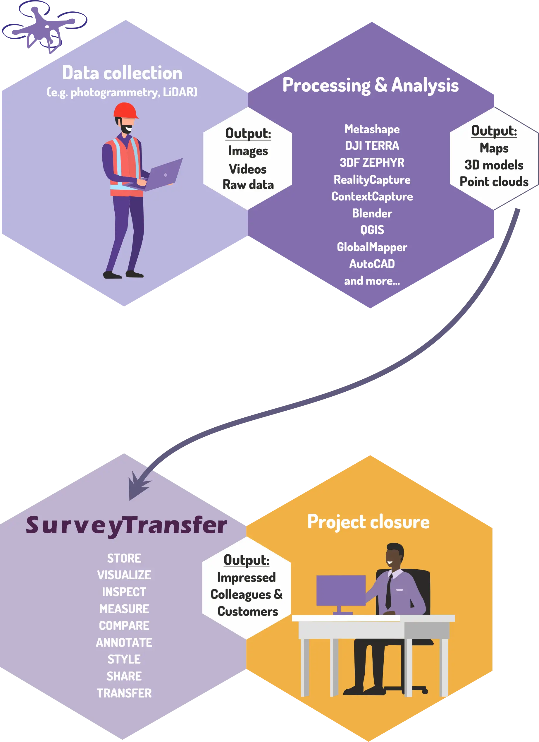
Effortless 3D Modelling Survey in 3 Easy Steps
Need more information? Read our ‘How to use’ documentation.
What Professionals Say About SurveyTransfer
“SurveyTransfer streamlined our drone-based 3D modelling surveys. Sharing and collaboration have never been easier!” — Lucas D., Survey Project Manager
“I use SurveyTransfer for promotions. We are a sensor manufacturer, and we embed SurveyTransfer views on our landing page to showcase the latest sensor data. It’s an effortless way to present our results in an interactive format!” — Daniel K., Marketing Manager
“We can easily manage to upload and share 75-80 GB GeoTIFF files. At first, I had doubts about this tool, but now I can’t imagine running our projects without it. SurveyTransfer has streamlined our workflow!” — Julia T., Remote Sensing Specialist
“I’m a freelance drone mapper, and I was looking for a tool to help my clients view high-resolution aerial maps. SurveyTransfer is super easy to use, and my clients love how intuitive the interface is!” — Rohit P., Freelance Drone Surveyor
“At the university, we wanted to showcase environmental studies to our students in an interactive way. SurveyTransfer has been an excellent demonstration and presentation tool for our research projects!” — Laura V., PhD
“I am a GIS Analyst at a small company. We mostly work with open-source software, but it’s hard to share maps and 3D data with non-GIS colleagues. SurveyTransfer provides a simple, powerful viewer that makes our data accessible to everyone!” — Sahil D., GIS Analyst
“We manage large-scale infrastructure projects and needed a tool to collaborate on aerial imagery and point clouds. SurveyTransfer allows our team to view and discuss survey data without requiring heavy software installations. It has transformed how we work!” — Emma R., Civil Engineer
Start Streamlining Your 3D Modelling Surveys Today
Make your 3D modelling surveys efficient and collaborative. Get started with SurveyTransfer now. Upload, visualize, and share your geospatial data today. Whether you’re a GIS professional, land surveyor, urban planner, or environmental researcher, SurveyTransfer ensures your data is always accessible and easy to manage.
✔ No software installation required
✔ Built-in map and 3D viewer
✔ Fast, secure, and user-friendly interface
Ready to experience seamless aerial map sharing?