
Data Sharing Platform - Real Geospatial Solutions
Modern geospatial projects require instant and secure sharing of large datasets. Securely share, visualize, and collaborate on geospatial data using SurveyTransfer’s intuitive data sharing platform. Easily manage permissions, visualize data online, and improve teamwork instantly. Share data securely and effortlessly, without technical barriers or size limitations. SurveyTransfer simplifies this process, allowing professionals to upload, manage, and share geospatial files quickly and securely.
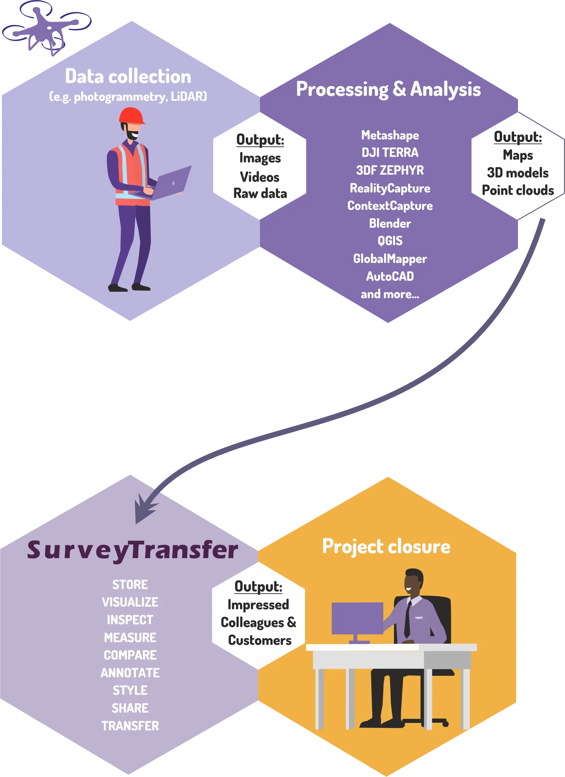
Why Use SurveyTransfer as a Geospatial Data sharing platform?
Flexible Data Sharing Platform Across Industries
GIS & Surveying
Simplify complex geospatial dataset sharing.
Engineering & Construction
Facilitate seamless collaboration on large CAD/BIM files.
Research & Education
Efficiently manage academic datasets for collaborative research.
Environmental Management
Share and visualize environmental data securely and instantly.
Start your Data Sharing Platform in 3 Easy Steps
Need more information? Read our ‘How to use’ documentation.
What Professionals Say About SurveyTransfer Geospatial Data sharing platform?
“SurveyTransfer changed how our team collaborates on large datasets. Secure, fast, and easy-to-use—highly recommended!” — Amanda L., Geospatial Analyst
“I use SurveyTransfer for promotions. We are a sensor manufacturer, and we embed SurveyTransfer views on our landing page to showcase the latest sensor data. It’s an effortless way to present our results in an interactive format!” — Daniel K., Marketing Manager
“We can easily manage to upload and share 75-80 GB GeoTIFF files. At first, I had doubts about this tool, but now I can’t imagine running our projects without it. SurveyTransfer has streamlined our workflow!” — Julia T., Remote Sensing Specialist
“I’m a freelance drone mapper, and I was looking for a tool to help my clients view high-resolution aerial maps. SurveyTransfer is super easy to use, and my clients love how intuitive the interface is!” — Rohit P., Freelance Drone Surveyor
“At the university, we wanted to showcase environmental studies to our students in an interactive way. SurveyTransfer has been an excellent demonstration and presentation tool for our research projects!” — Laura V., PhD
“I am a GIS Analyst at a small company. We mostly work with open-source software, but it’s hard to share maps and 3D data with non-GIS colleagues. SurveyTransfer provides a simple, powerful viewer that makes our data accessible to everyone!” — Sahil D., GIS Analyst
“We manage large-scale infrastructure projects and needed a tool to collaborate on aerial imagery and point clouds. SurveyTransfer allows our team to view and discuss survey data without requiring heavy software installations. It has transformed how we work!” — Emma R., Civil Engineer
Start Sharing your geospatial datasets with Ease
Make your data sharing effortless, secure, and collaborative. Get started with SurveyTransfer now. Upload, visualize, and share your geospatial data today. Whether you’re a GIS professional, land surveyor, urban planner, or environmental researcher, SurveyTransfer ensures your data is always accessible and easy to manage.
✔ No software installation required
✔ Supports large file sizes up to 100 GB
✔ Fast, secure, and user-friendly interface
Ready to experience seamless aerial map sharing?