
A GeoTIFF is a specialized raster file format commonly used in Geographic Information Systems (GIS) and remote sensing. It embeds geographic metadata into TIFF images, enabling accurate mapping and geospatial analysis. GeoTIFFs serve various industries, including agriculture, environmental management, urban planning, and disaster response.
Managing and sharing these files can be challenging due to their complexity and large size. SurveyTransfer provides a streamlined solution for visualizing, managing, and sharing these files effectively online. This article explains what GeoTIFF files are, how they work, their key uses, and how SurveyTransfer improves workflows involving these files.
What is a GeoTIFF?
A GeoTIFF file is essentially a georeferenced TIFF (Tagged Image File Format). Unlike standard TIFF files, GeoTIFF includes geographic metadata like coordinate reference systems (CRS), map projections, and georeferencing data. This allows GIS software to accurately place the image geographically without needing additional reference files.
The format is popular because it supports high-resolution raster data essential for detailed geographic analyses and applications.
GeoTIFF vs TIFF: Understanding the Difference
While both GeoTIFF and TIFF formats store raster images, GeoTIFF is unique in embedding geographic data. Regular TIFF images lack this embedded spatial referencing, requiring separate referencing files to integrate with GIS. The integrated metadata in GeoTIFF files significantly streamlines GIS workflows, enabling faster integration and accurate mapping.
Viewing and Analyzing
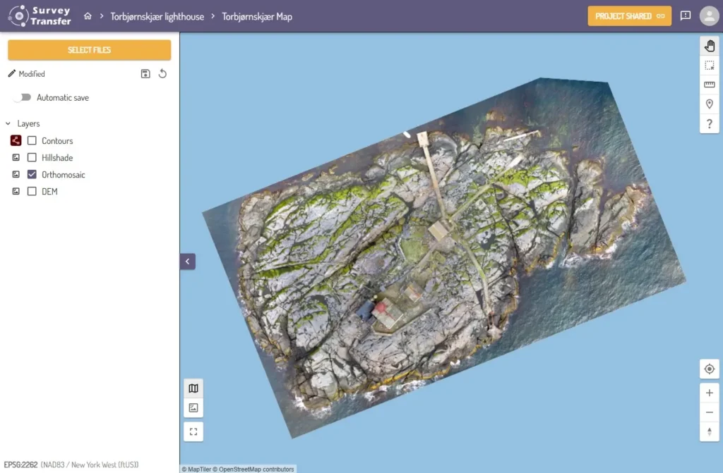
Traditionally, viewing GeoTIFF images required specialized GIS software, complicating quick file access and sharing. SurveyTransfer solves this problem by offering an intuitive, web-based viewer. This allows users to visualize and analyze the images directly in their browsers, making data inspection and collaboration simpler.
According to SurveyTransfer’s detailed guide on built-in viewing capabilities, this approach significantly enhances collaboration, real-time visualization, and streamlined data management.
Applications Across Industries
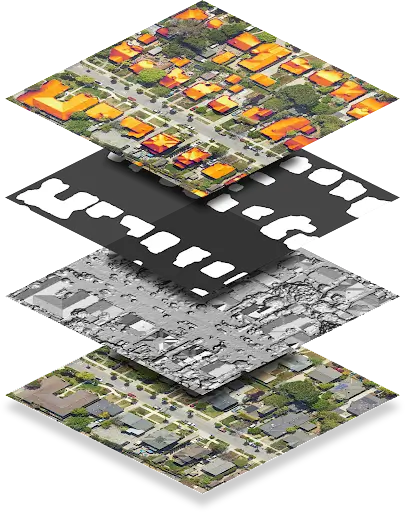
GeoTIFF files have versatile applications in numerous sectors. In agriculture, they support precision farming with satellite imagery and digital elevation models (DEMs). Environmental management professionals use them to monitor ecological changes, habitats, and spatial risk assessments. Urban planners rely on GeoTIFF images for accurate city mapping, infrastructure planning, and land-use studies. Additionally, these files are crucial in disaster management for rapid emergency assessments and are fundamental in remote sensing for detailed satellite imagery analysis.
Benefits of Using GeoTIFF Files
They seamlessly integrate with nearly all GIS and remote sensing applications, ensuring accurate spatial referencing due to embedded metadata. The high-quality raster data contained in GeoTIFFs supports precise geographic analyses. Furthermore, their robust structure ensures consistent and reliable performance across different platforms and use cases.
Sharing and Collaborating Using SurveyTransfer
Traditionally, sharing GeoTIFF data has been challenging because of large file sizes and software dependencies. SurveyTransfer simplifies this by providing secure cloud storage and an easy-to-use sharing platform. The built-in viewer allows direct visualization without additional software, improving collaboration and accessibility significantly.
SurveyTransfer’s comprehensive guide on sharing GeoTIFF files details how the platform simplifies collaboration, data handling, and visualization.
Conclusion
GeoTIFF files are crucial for effective spatial analysis and geographic information systems due to their embedded geographic metadata, broad compatibility, and diverse applications.
SurveyTransfer further enhances these advantages by making geospatial file visualization, sharing, and collaboration more accessible and efficient, enabling better geospatial workflows.
Ready to optimize your geospatial workflows? Get started with SurveyTransfer today!
If you really liked what you read than you can share it with your friends. 🙂
Did you like what you read? Do you want to read similar ones?