
Drone roof inspection is currently one of the most common types of inspections carried out with drones. Just a few years ago, the use of drones for roof surveys and analysis was merely an idea rather than a common practice.
In this guide about drone roof inspection, we will overview the role and advantages of drones, the steps of roof surveying and inspection, as well as present a solution for roof analysis and report generation.
Sidenote: This article is the result of a creative cooperation between SurveyTransfer and AeroDetect. Together we developed a QGIS based roof analysis module. We give the QGIS script and templates – roof analysis and report generation as a gift. You can download it here.
In the roof analysis and report generation chapter, we show how to perform a complex roof analysis and create a report from the results of a drone roof inspection in QGIS. A little taste of the QGIS roof analysis module developed by SurveyTransfer.
If you’re a drone pilot who does drone roof inspection projects or want to learn more about the roof inspection proces than you’ve come to the right place!
What is drone roof inspection and roof analysis?
During drone roof inspection, data is collected about the condition of the roof, which is then used to create images, maps, and 3D files. The generated maps and 3D files provide valuable information after specific roof analysis. In the end, a report is compiled from these findings.
Typically, two types of cameras are used for aerial roof surveys. Depending on the type of survey needed, either an RGB wide-angle camera or a thermal camera can be used.
Sidenote: Roof inspection can also be done with LiDAR, but here visual information in true color is more important! Photogrammetric surveys using an RGB camera are more common in drone roof inspection.
Why is drone roof inspection useful? What are its advantages?
Without a drone, the traditional method of roof inspection involves a person climbing onto the roof using a ladder and looking around. This is not very safe and not representative, as many parts of the roof may be dangerous and inaccessible. In contrast, during drone roof inspection, the drone pilot can safely, extremely efficiently, and accurately survey the entire roof surface in detail.
The steps of drone roof inspection and survey
Here are all the steps you should keep in mind during a drone roof survey:
1 – USE A CHECKLIST
Before the survey, make sure everything is ready:
- Make sure the drone batteries and spare batteries are fully charged.
- Check the drone’s memory card for enough free space to store the collected data.
- Check the drone camera settings to ensure it is ready to take the necessary shots.
- Check the drone’s sensors, propellers, and all accessories.
- Make sure the weather will be suitable for flying.
- Do you have all the necessary permissions to fly in that airspace?
2 – SAFETY MEASURES AND LEGAL COMPLIANCE
- Always prioritize safe flying, and before starting the survey, check the area to avoid collisions or accidents that could result in property damage or injuries.
- Do you have the appropriate certification and drone license?
- Make sure you comply with local regulations regarding drones.
3 – PLAN YOUR FLIGHT
- Use aerial mapping software to plan the drone’s flight path. The route should thoroughly cover the roof and capture it from multiple viewpoints.
4 – Start the survey
- Remember to take high-quality photos and/or videos of the entire roof with the drone.
5 – CREATE MAPS, 3D FILES, AND OTHER DELIVERABLES
You can vreate maps and 3D files from drone roof inspection using photogrammetry software. Once you have all the photos, videos, 3D models, orthomosaic, digital elevation model (DEM), or other outputs, it’s time to analyze them. Roof analysis typically includes the following elements:
- Identification and mapping of roof sections
- Determination of roof surface dimensions
- Determination of roof edge lengths
- Determination of roof section angles
- Identification of the location and size of objects on the roof (chimneys, roof vents, antennas, skylights, etc.)
- Creation of slope maps
- Creation of 3D roof drawings for planning
- Roof condition assessment: documenting surface damage such as cracks, missing shingles, roof tiles, or other issues related to roofing materials
6 – GENERATE A REPORT
Using the output files, compile a report detailing the key findings of the drone roof inspection.
Roof analysis and the report generation
During roof analysis, measurements (e.g., angle of a slope, 3D area, height data, 3D length measurements) and report preparation require time-consuming manual work. To automate this process, we have written a script in QGIS that automatically generates the necessary output files and performs the measurements. In addition, we have created a report template that allows you to create a report in minutes. As a result, depending on the complexity of the project, you can save up to 8 hours during one project! You can download the scipt and templates here.
What do you need to perform roof analysis in QGIS?
You need the roof orthophoto (or orthomosaic) and the roof digital elevation model (DEM). The SurveyTransfer team provides the following:
- Pre-made QGIS project (Roof_Analysis_Report_Template.qgz) including the report template.
- QGIS style files for thematic representation of roof edges and roof surfaces (roof_line_style.qml; roof_polygon_style.qml).
- Script carrying out measurement of roof parts (roof_analysis_process.py).
- Detailed 10-minute tutorial video on how to use the module.
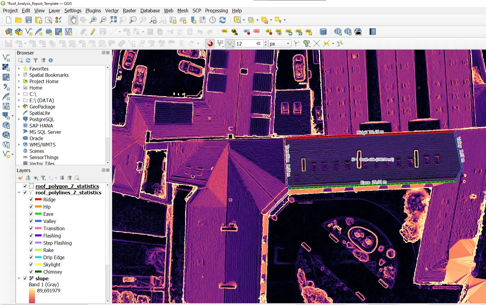
How does QGIS roof analysis work?
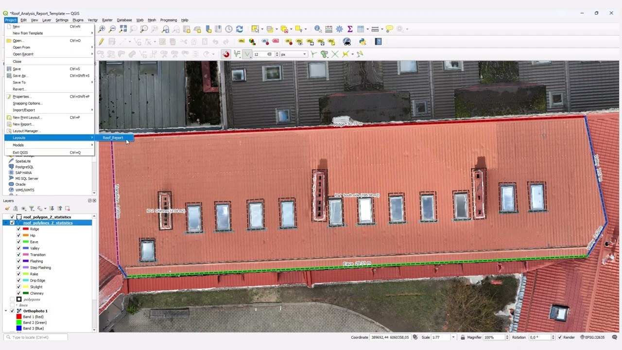
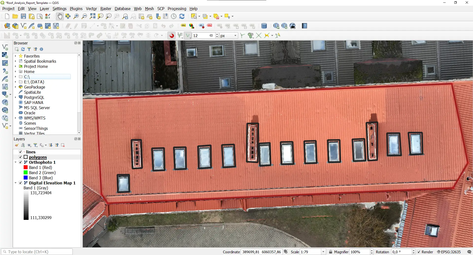
You need to create two shapefiles in the attached QGIS project file. One shapefile is for drawing the roof surface, and another separate shapefile is for the roof edges. Drawing roof parts on the orthophoto in map view is much simpler and faster than on a 3D file, so we are saving you some time! 🙂
Start the script and provide the necessary data. The results of the script will be generated in the „Select Folder for Outputs” folder.

Two shapefiles appear as a result. These are thematically styled files that already contain the most important roof parameters.

The script not only performs calculations, but also converts! It converts 2D drawings into 3D planes based on the DEM, so you can use the files for planning and further 3D analysis.

Report template in QGIS
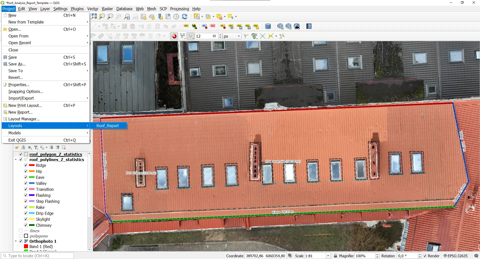
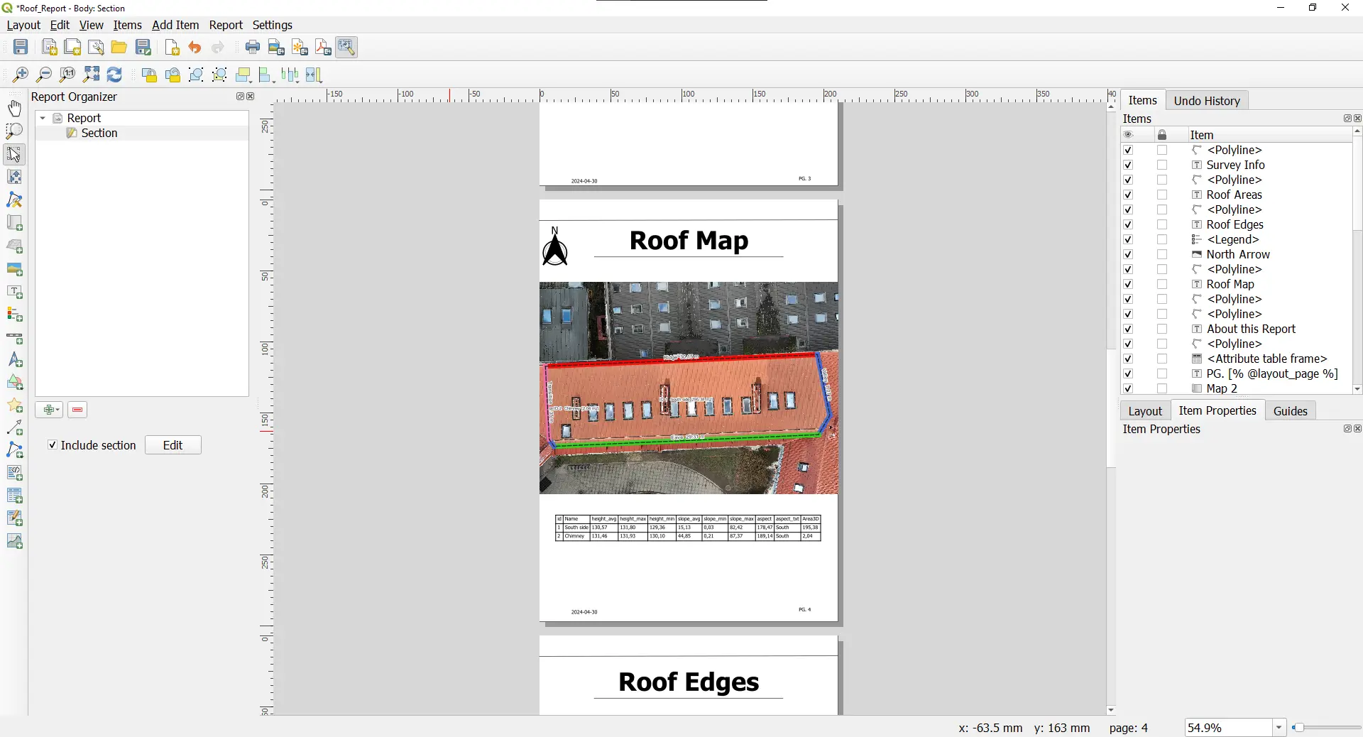
You can find the report template created by us under the menu item Project/ Layouts/ Roof_Report (it is part of the Roof_Analysis_Report_Template.qgz QGIS project file).
Thanks to the report template, you can create a ready-made report with just a few minutes of effort. The report interactively reflects the displayed QGIS map content. Additionally, the content of the report is fully customizable and you can export it as a PDF.
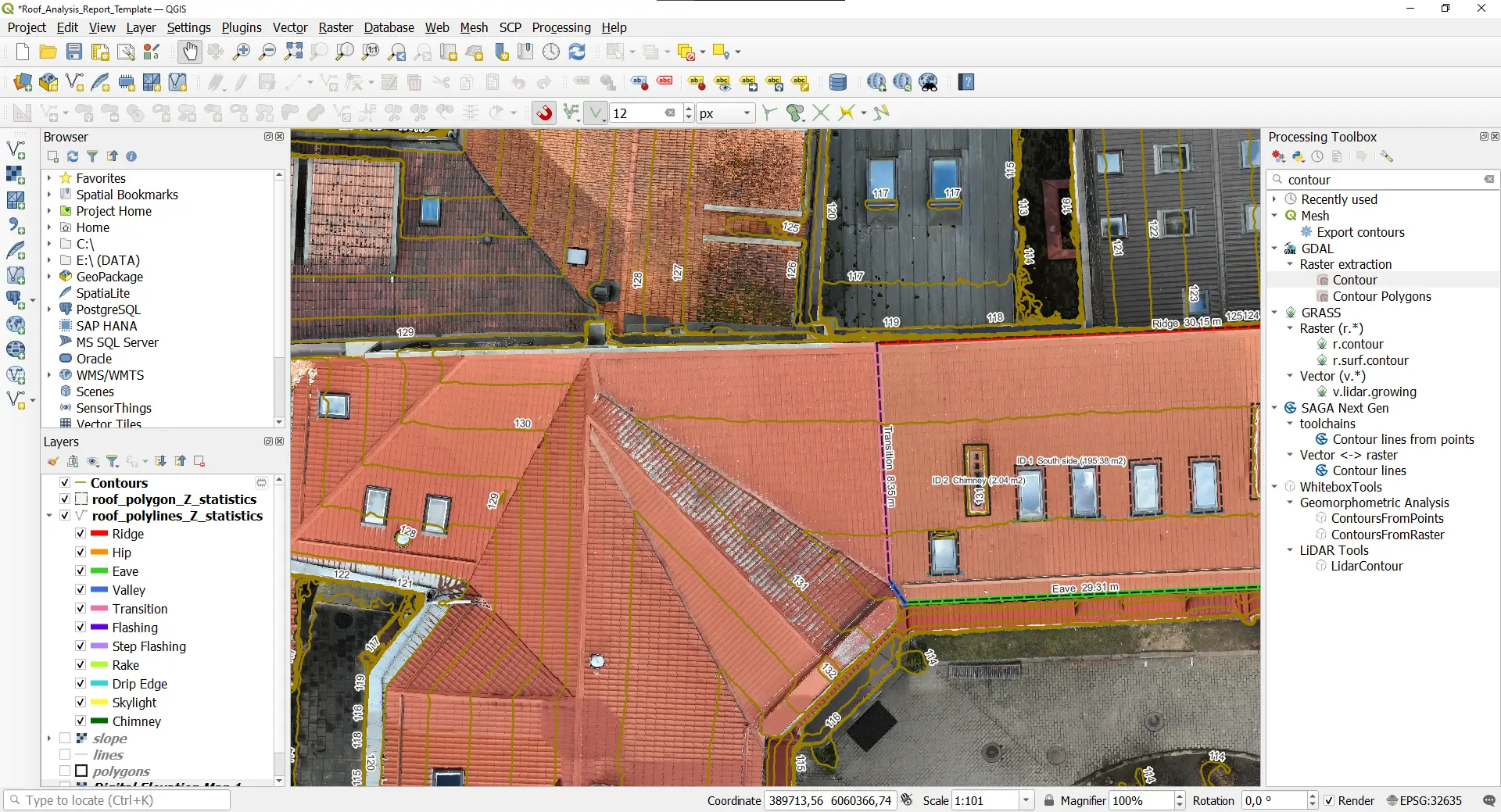
Advanced Roof Analysis in QGIS
The results of the roof_analysis_process.py script will not only be shapefiles but also an exposure map (aspect) and a slope map. With the slope map, it is possible to visually represent the slope of roof sections (e.g. larger and smaller slopes) with just a few clicks.
If you would also like to create a contour map, it is enough to run the “Contour” function on the DEM. Of course, you can also include these in the report!
Sharing the results of the drone roof inspection
For the professional sharing of the results of the drone roof inspection – aerial photos, videos, orthophotos, DEMs, 3D models, shapefiles and also PDF reports – it is practical to use SurveyTransfer. With SurveyTransfer, you can not only transfer the data, but also display it online without external software!

If you really liked what you read than you can share it with your friends. 🙂
Did you like what you read? Do you want to read similar ones?