
Are you curious about how high-quality imagery is captured and its impact on aerial surveys? Look no further! In this article, we will delve into the concept of Ground Sample Distance (GSD) and take a closer look at how it influences the quality and resolution of aerial and satellite imagery.
GSD is a vital parameter that measures the distance on the ground represented by each pixel in an image. By understanding GSD, we gain valuable insights into the level of detail and accuracy captured by various imaging technologies. Whether you’re a photography enthusiast, a drone pilot or a GIS professional, this article will shed light on how GSD impacts the information we derive from imagery.
Through a comprehensive exploration of ground sample distance, we’ll discuss how GSD plays a crucial role in the recognition of objects and the ability to extract meaningful insights from imagery. Get ready to uncover the mysteries behind high-quality imagery and the critical role GSD plays in capturing the world around us.
But remember, high resolution images (low GSD) result in large maps and 3D files that need to be stored and shared with others somehow! We developed SurveyTransfer to store, share and view large geospatial files on the web.
How to Calculate Ground Sample Distance
Ground Sample Distance (GSD) is a fundamental concept in photogrammetry and remote sensing. It refers to the size of the ground area represented by a single pixel in an image. By calculating the GSD, we can determine the level of detail captured by the camera or sensor.
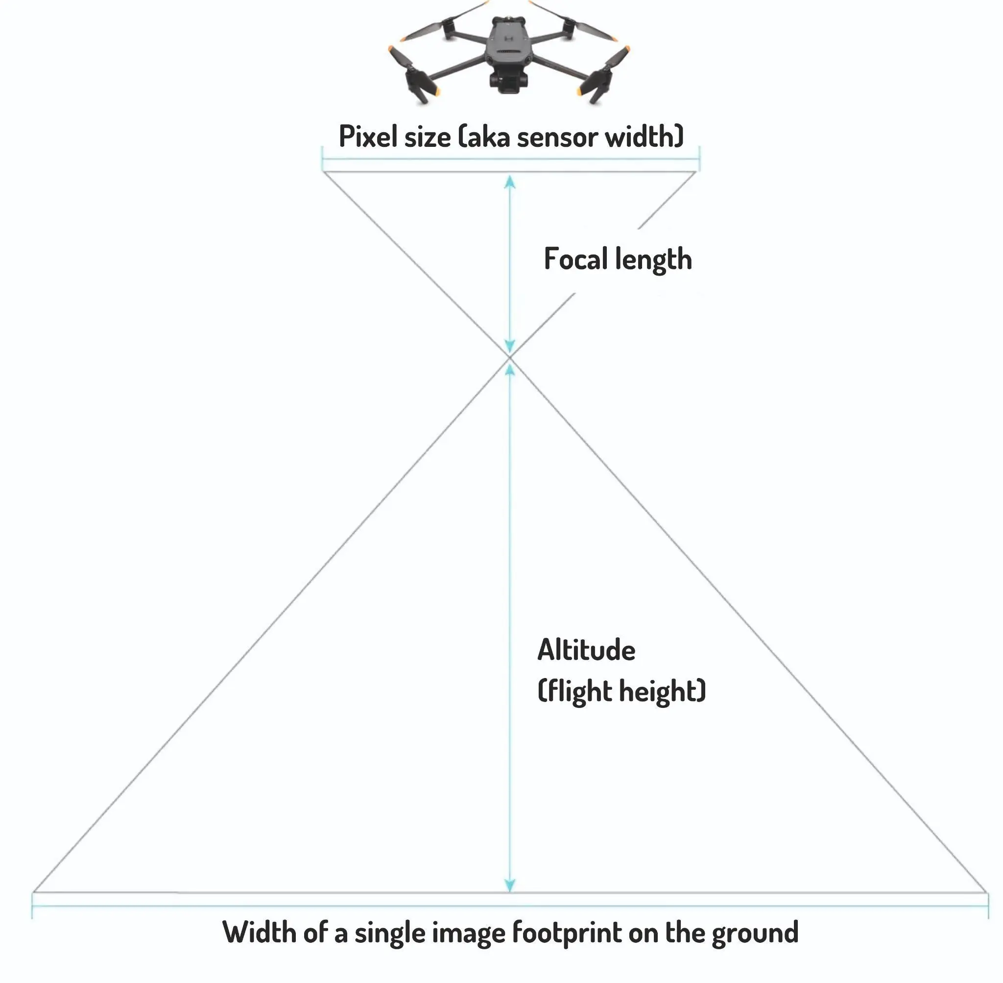
To calculate the GSD, we need to know the focal length of the camera, the altitude of the platform (such as a drone or satellite), and the size of the image sensor. The formula for calculating GSD is as follows:
GSD = (focal length * pixel size) / altitude
If you want to calculate the width of single image footprint on the ground (meters) and height of single image footprint on the ground (meters), you can do it with the following formula:
Width of single image footprint on the ground = (GSD * Image width (pixels)) / 100
Height of single image footprint on the ground = (GSD * Image height (pixels)) / 100
The focal length is the distance from the camera lens to the image sensor. The pixel size is the physical size of a single pixel on the image sensor, usually measured in micrometers. The altitude is the height above the ground at which the image is captured.
By plugging in these values into the formula, we can determine the GSD of an image. For example, let’s say we have a drone with a 20-megapixel camera, a focal length of 24mm, a pixel size of 1.5 micrometers, and an altitude of 100 meters. Using the formula, we can calculate the GSD as follows:
GSD = (24mm * 1.5 micrometers) / 100 meters = 0.36 meters/pixel
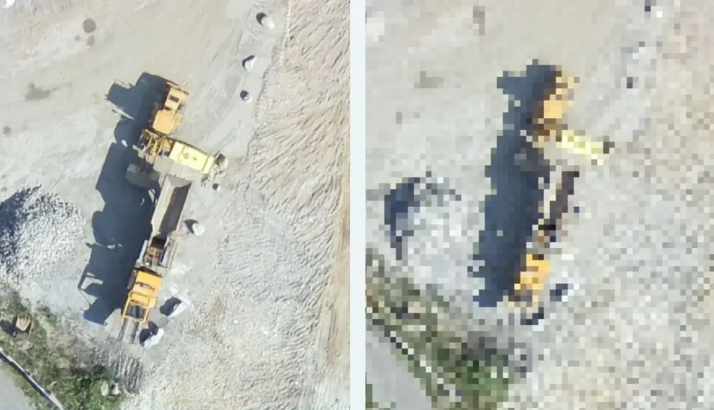
This means that each pixel in the image represents 0.36 meters on the ground. The smaller the GSD, the higher the resolution and level of detail in the image.
Understanding how to calculate GSD is essential for anyone working with aerial or satellite imagery. It allows us to determine the level of detail captured by different sensors and helps us make informed decisions when selecting the right imaging technology for specific applications.
Factors Affecting GSD
Several factors can influence the Ground Sample Distance (GSD) of an image. Understanding these factors is crucial for capturing high-quality imagery and extracting accurate information from it.
- Altitude: The altitude at which the image is captured plays a significant role in determining the GSD. As the altitude increases, the GSD becomes larger, resulting in lower resolution and less detail in the image. On the other hand, a lower altitude leads to a smaller GSD, resulting in higher resolution and finer detail.
- Focal Length: The focal length of the camera lens also affects the GSD. A shorter focal length captures a wider field of view, resulting in a larger GSD and lower resolution. Conversely, a longer focal length narrows the field of view, resulting in a smaller GSD and higher resolution.
- Pixel Size: The physical size of the pixels on the image sensor plays a crucial role in determining the GSD. Smaller pixel sizes result in smaller GSDs and higher resolution, as more pixels can fit within the same area. Larger pixel sizes lead to larger GSDs and lower resolution.
- Sensor Size: The size of the image sensor also impacts the GSD. Larger sensors can capture more detail and have smaller GSDs, resulting in higher resolution images. Smaller sensors, on the other hand, have larger GSDs and lower resolution.
By considering these factors, photographers, drone pilots, and GIS professionals can optimize their imaging setup to capture high-quality imagery with the desired level of detail and resolution.
Understanding Ground Sample Distance and Its Role in Imagery
A smaller GSD indicates higher resolution and finer detail, enabling us to identify and analyze smaller objects in the image. For example, in the field of agriculture, a low GSD can help identify individual plants or detect early signs of crop diseases. In urban planning, a high-resolution image with a low GSD allows us to analyze building footprints and identify potential areas for development.
On the other hand, a larger GSD may be sufficient for certain applications where a high level of detail is not required. For example, in large-scale mapping projects, a higher GSD can provide a broader overview of the area of interest without sacrificing too much accuracy.
It’s important to note that GSD is not the only factor that determines the quality of imagery. Other factors, such as lighting conditions, atmospheric effects, and post-processing techniques, also play a significant role. However, GSD serves as a fundamental parameter for understanding the level of detail and accuracy captured by imaging technologies.
By understanding the concept of GSD and its role in imagery, we can make informed decisions when selecting the right imaging technology for specific applications.
Software for Sharing Maps with Low GSD
As mentioned earlier, high-resolution images with low GSD result in large maps and 3D files that need to be stored and shared with others. Traditional methods of sharing such large geospatial files can be cumbersome and time-consuming. However, there are software solutions available that make the process more efficient and accessible.
One such software is SurveyTransfer. SurveyTransfer is a web-based platform designed specifically for storing, sharing, and viewing large geospatial files on the web. It provides an easy-to-use interface for uploading and managing high-quality multi-10GB files made with a low ground sample distance.
With SurveyTransfer, you can securely store your high-resolution maps and 3D files in the cloud, eliminating the need for physical storage devices. You can easily share these files with colleagues, clients, or stakeholders by simply providing them with a link. SurveyTransfer also provides advanced visualization capabilities, allowing users to view and interact with the geospatial data directly in their web browser.
By using software like SurveyTransfer, you can overcome the limitations of file size and easily share your high-quality geospatial files with others. Whether you’re working on large-scale mapping projects, conducting detailed surveys, or collaborating with remote teams, SurveyTransfer provides a seamless solution for storing and sharing high-resolution imagery with low GSD.
If you really liked what you read, you can share it with your friends. 🙂
Did you like what you read? Do you want to read similar ones?