
What formats does SurveyTransfer support?
With SurveyTransfer, files with any extension can be shared, but only spatial data formats can be displayed on map or in 3D. This means that any file format, such as images, videos, text files, etc. can be uploaded, but only files with geometric content can be displayed on maps or in 3D. The following discussion will focus on spatial data formats only.
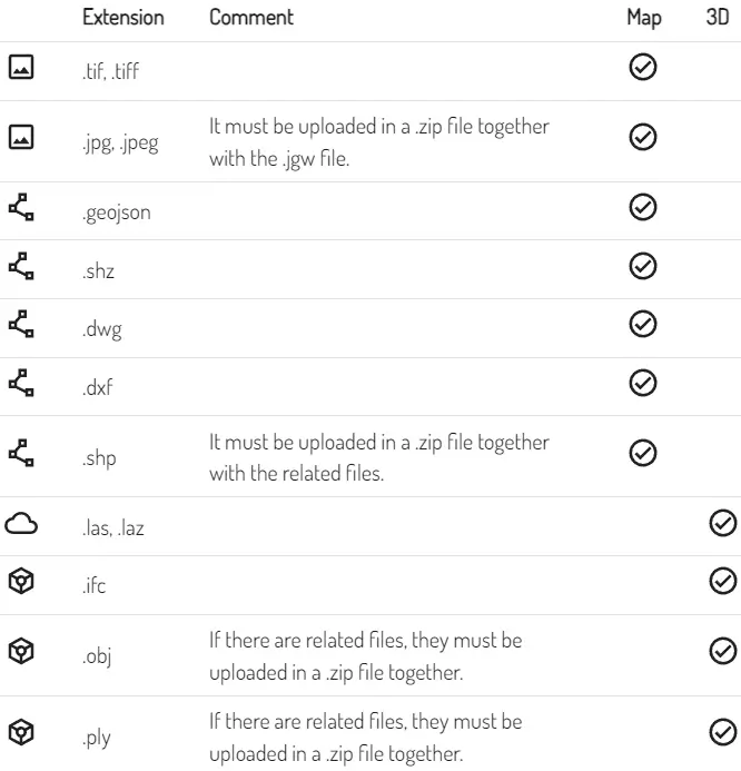
We are continuously expanding the list of spatial data file formats supported by SurveyTransfer! Currently (as of 02.01.2024), the following map and 3D elements are supported:
There are also requirements regarding coordinate reference systems (CRS). If a file does not contain CRS information, it will either be assigned the project CRS (specified during project setup) or, if no CRS is specified for the project, the file will be assigned the World Geodetic System 1984 (WGS84; EPSG:4326) CRS by default.
There are formats which require multiple files (e.g., shapefile, obj with texture), in this case these files must be uploaded together in a ZIP in order to be processed correctly. If there is a file format that you miss, then write to us HERE!
SurveyTransfer plans
The SurveyTransfer team allows users to use our plan that provides 250 GB of storage space for free for 14 days as a demo. When you register, the free version of SurveyTransfer is automatically activated for you, so you can try our service. After the time limit expires, the uploaded files will be deleted, and the account will be locked. If someone subscribes after the free trial period, their account will be activated again, and they can continue to use SurveyTransfer geospatial data sharing platform for the subscription period with the quota defined in the selected plan.
There may also be a case where one of our subscribers decides to switch plans. If they want to switch to a larger plan, they can easily upgrade their subscription. If they want to switch to a smaller plan, that is also possible, but they should be careful not to exceed the storage limit of the smaller plan when downgrading. If the storage space used exceeds the quota of the smaller plan, the user must delete enough files to fit within the smaller plan before being able to downgrade. For details, please read the General Terms and Conditions!
If a user’s subscription expires, we will notify them twice by email within 7 days to renew their subscription. If they do not comply, the files stored in their account will be completely deleted, and their account will be locked.
File processing in SurveyTransfer
The spatial files uploaded to SurveyTransfer are processed automatically to make them ready to be added to map or 3D view. One or more files may be uploaded at once, and SurveyTransfer is capable of processing geospatial files continuously and in parallel.
Processing the files requires significant hardware resources, so users trying out the free plan may have to wait in certain cases until some server capacity becomes available. If the servers are overloaded, an alert will appear in the web app. Our subscribers have the privilege of being prioritized in the processing queue: the files they upload will be processed before the files uploaded by free plan users.
Supported browsers
During detailed testing of SurveyTransfer, we did not experience any errors using the following browsers: Safari, Google Chrome, Mozilla Firefox and Microsoft Edge. If you notice any abnormal operation, please write to us on our error reporting interface (https://surveytransfer.net/feedback).